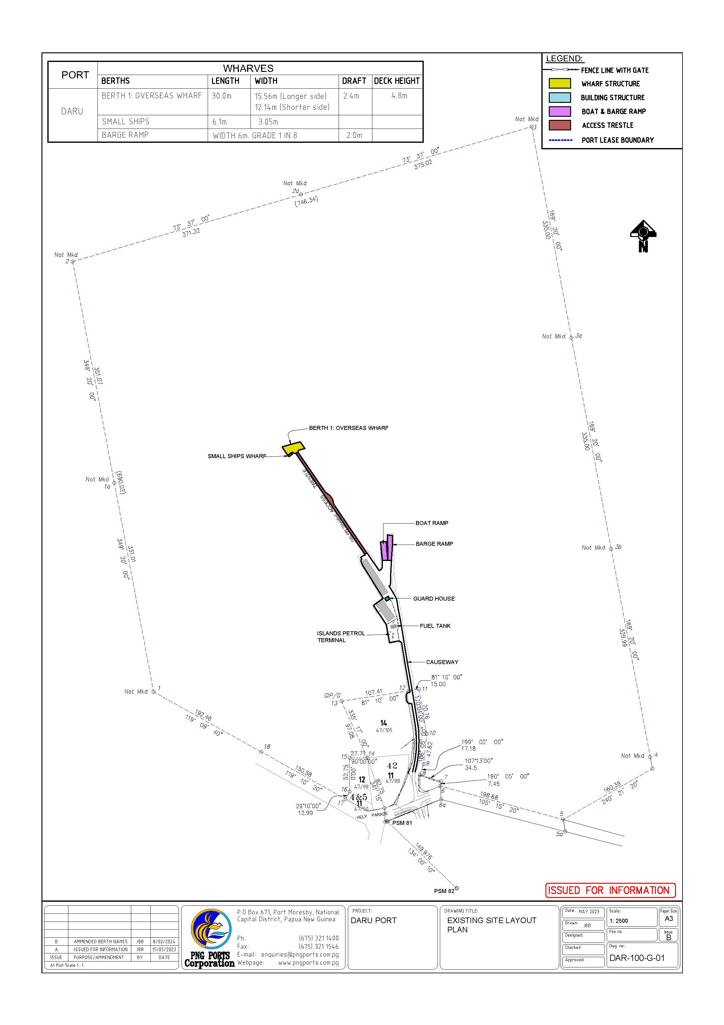
PORT OF DARU
Daru Port (above) The Daru Port (as shown above) is situated on Daru Island and is near the mouth of the famous Fly River in the Western Province, Papua New Guinea.
Daru is situated on the North of Torres Strait and far North Queensland and is the second largest southern coastal settlement in Papua New Guinea after Port Moresby.
GENERAL PORT INFORMATION
Location | Latitude: 09° 50.4'S Longitude: 143°12.6'E |
Chart No. | AUS 840 |
Regional Port | Port Moresby |
Time Zone | Local time is 10 hours ahead of GMT |
Radio Communication | Call Daru Port control on VHF 16/69/72 |
Customs | Port of entry |
Pilotage | Pilotage is not available. Pilot available on request from Port Moresby |
Tugs | None available |
Bunkers | Fuel: Available in drums and bulk. Supplier: Mayfuel Distributoer Ltd. |
Fuel | Available in drums and bulk. Supplier: Mayfuel Distributoer Ltd. |
Water | No water service |
WHARF FACILITIES
CRANE
There are no wharf mounted cranes at current. However, forklifts are used instead to remove consignments as all TEUs are unpacked on board the vessel through the ramp. Once the trestle is rehabilitated, mobile cranes may be available. Shippers are advised though to check this before shipping and with heavier loads prior advice and approval must be sought from the relevant Port Authority.
STORAGE AREA
Open storage 1,000 sq.m
BUNKER PROVIDER
Available in drums and bulk. Supplier: Mayfuel Distributor Ltd
WATER PROVIDER
No waste disposal facility is available. Arrangement for disposal can also be done with the Shipping Agents and Department of Health (Quarantine Section).
BULK HANDLING, WATER PROVIDER, RO-RO, TANKER, SLIPWAY, SHIP REPAIRS & MAINTENANCE, LNG (Liquefied Natural Gas), PASSENGER HANDLING, HEAVY LIFT AND STEVEDORE PROVIDER
The above mentioned facilities are not available. For further clarification - advice on the mentioned facilities must be obtained from the Executive Manager (Operations) or the respective Port Manager prior to any shipment.
WHARF TECHNICAL INFORMATION
Berth | Length | Width | Water Depth (below LAT) | Deck Height (Above LAT) |
|---|---|---|---|---|
Berth 1 (Main Wharf) | 30m | 12.2m | 2.4 LAT (Obtained from periodic data) | 4.8m |
Barge (Ramp) | Width 6m Grade 1 in 8 |
WHARVES PERMISSIBLE LOADINGS
Note: Berth 1 – while awaiting a major Trestle Rehabilitation, NO road vehicles of any kind is allowed at current. Only passengers are allowed. To discharge and load cargoes, the Barge Rumps (1 and 2) are used instead.
PERMISSIBLE LOADINGS
Berth | Distributed Tons per sqm | Road Vehicle | Road Vehicle | Road Vehicle |
|---|---|---|---|---|
Truck | Semi-trailer | Forklift | ||
Berth 1 | 1.5 | T6 | - | F2.5 |
PILOTAGE
PILOTAGE AUTHORITY
PNG Ports Corporation Limited. Pilotage is not available. Pilot are available on 48 hours notice from Port Moresby.
TUG, TOAWAGE, BARGES AND MOORING GANGS
Privately owned and operated at some ports under licenses issued by the PNG Ports Corporation Limited. Arrangements can be made with Private Operators through respective shipping agents
BOARDING STATION
Lat: 09° 50.4'S. Long: 143° 12'.6E, Bristow Island Light Bearing 290° Tx 2.70 M, AUS Chart: 840
OR BAD WEATHER
Lat: 09 06'.8S. Long: 143 19'.4E, Bristow Island Light Bearing 290° Tx 2.70M. AUS Chart: 840
COMMUNICATION ARRANGEMENTS
Daru Port Control on V.H.F 16/69/72
Tug, Towage, Barges and Mooring Gangs
Privately owned and operated under license issued by the PNG Ports Corporation Limited. Arrangements can be made with Private Operators through respective shipping agents.
CONTACT INFORMATION
PNG Ports Corporation Limited
Daru Port
P. O. Box 48
Daru, Western province
Papua New Guinea
Telephone:+675 645 9137
Email: enquiries@pngports.com.pg
Official | Office |
|---|---|
Business Manager | +675 645 9137 / 7351 5931 |
Pilot (Marine) | Refer to Port Moresby |
customs (Collector) | +675 645 9114 |
Health Officer | +675 645 9246 |
Quarantine Officer | +675 645 9048 |
Fire | NIL |
Police | +675 645 9022 |
Ambulance | +675 645 9166 |
Emergency | +675 645 9166 |
DARU PORT LAYOUT

