PORT OF LORENGAU
Lorengau Port is in the Manus province of Papua New
Guinea. Lorengau is located on the edge of Seeadler
Harbor on Manus Island, in the Admiralty Islands.
GENERAL PORT INFORMATION
Location | Latitude: 02° 000.08'S Longitude: 147° 16.3'E |
Chart No. | AUS 662 |
Regional Port | Port Madang |
Time Zone | Local time is 10 hours ahead of GMT |
Radio Communication | Call "Lorengau Port Control" on VHF 16/12 |
Customs | Port of entry |
Pilotage | Pilotage not compulsory. Pilot is available at 48 hours Notice from Madang & Lae. |
Tugs | None available |
Bunkers | Fuel: Diesel available by road tanker at Berths 1–2 and by pipe line at Berth 1. Suppliers: Pokapin Enterprises (Inter Oil agent). Water is supplied on request by the Port Authority. |
WHARF FACILITIES
CRANE
There are no wharf mounted however, mobile are available
capable of lifting up to 20 tonne containers. Shippers are
advised though to check this before shipping heavier loads. Prior advice and approval must be sought from the relevant Port Authority.
STORAGE AREA
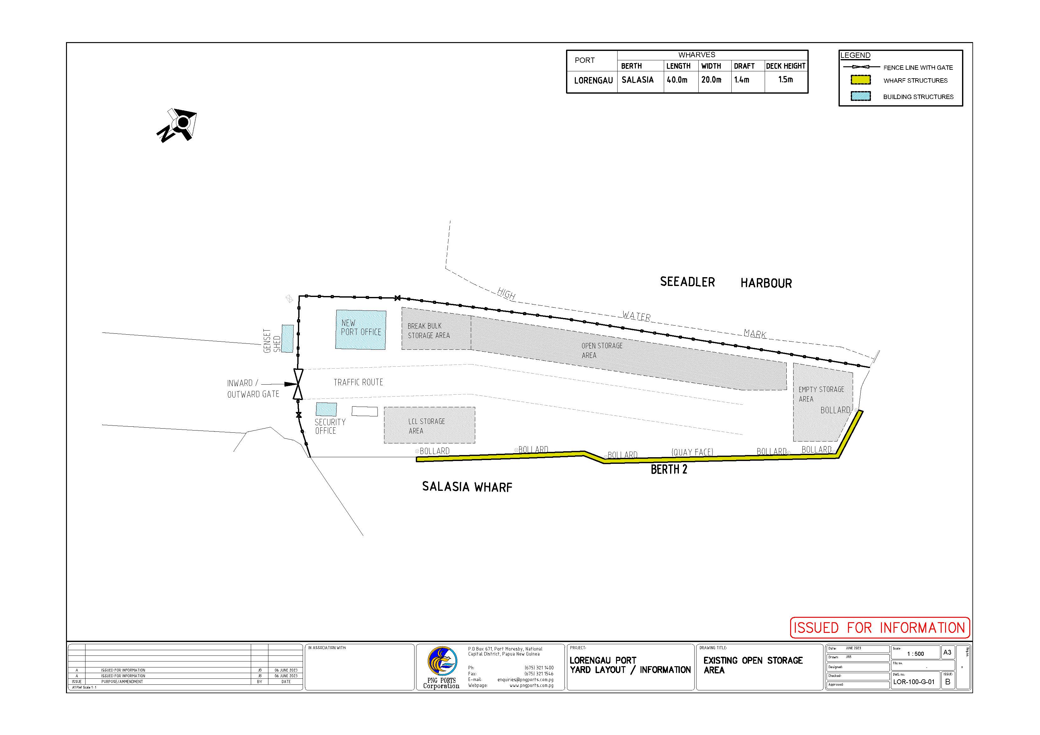
No under cover storage. Open storage 1,000sq.m.
TANKER FACILITY
All discharge facilities at the Nabu Wharf.Only 1 shed to store break bulk cargoes.
LNG (Liquefied Natural Gas)
One 54.86mtrs berth depth 6.10mtrs.
BUNKER PROVIDER
Diesel available by road tanker at Berths 1–2 and by pipe line at Berth 1. Suppliers: Pokapin Enterprises (agent).
WATER PROVIDER
Water is supplied on request by the Port Authority.
SLIPWAYS, SHIP REPAIRS & MAINTENANCE
A new dry dock facility is in operation at Motukea (Port Moresby) by Curtain Brothers (PNG) Ltd.
WASTE DISPOSAL
No waste disposal facility is available. Arrangement for disposal can be made with the Shipping Agent and National Agriculture and Quarantine Inspection Authority (NAQIA).
BULK HANDLING, RO-RO, LNG (Liquefied Natural Gas), PASSENGER HANDLING, HEAVY LIFT, AND STEVEDORE
PROVIDER
The above mentioned facilities are not available. For further clarification - Advice on the mentioned facilities must be obtained from the Executive Manager (Operations) or the respective Port Manager prior to any shipment.
WHARF TECHNICAL INFORMATION
Berth | Length | Width | Water Depth (below LAT) | Deck Height (Above LAT) |
|---|---|---|---|---|
Berth 1 (Nabu Wharf) | 15m | 9.1m | 5.1m | 2.9m |
Berth 2 (Salasia Wharf) | 40m | 20m | 1.4m | 1.5m |
PERMISSIBLE LOADINGS
Berth | Distributed Tons per sqm | Road Vehicle | Road Vehicle | Road Vehicle |
|---|---|---|---|---|
Truck | Semi-trailer | Forklift | ||
Berth 1 | Loading Restricted | |||
Berth 2 | 0.97 | T13 | - | F16 |
PILOTAGE
PILOTAGE AUTHORITY
PNG Ports Corporation Limited. Pilotage not compulsory. Pilot is available at 48 hours Notice from Madang/Lae.
BOARDING STATION
Lat: 02°56.65 S, Long: 147° 18'.29 E, Old Light Ho (Ndrilo Is) Bearing 126° (T) x 2.90M
OR BAD WEATHER
Lat: 02°56.65 S, Long: 147° 18'.29 E, Old Light Ho (Ndrilo Is) Bearing 126° (T) x 2.90M
COMMUNICATION AGREEMENTS
Call "Lorengau Port Control" on VHF 16/12.
TUG, TOWAGE, BARGES AND MOORING GANGS
Privately owned and operated under license issued by the PNG Harbours Board. Arrangements can be made with Private Operators through the respective Shipping Agents.
CONTACT INFORMATION
PNG Ports Corporation Limited
P. O. BOX 21
Lorengau, Manus Province
Papua New Guinea
Telephone:+675 970 9060
Facsimile:+675 970 9321
Email: enquiries@pngports.com.pg
Official | Office |
|---|---|
Business Manager | +675 970 9078/710 32034 |
Pilot (Marine) | +675 472 2477 (Lae) |
Customs (Collector) | +675 970 9195/068 |
Health Officer | +675 970 9787 |
Quarantine Officer | +675 970 9294 |
Fire | Nil |
Police | +675 970 9122 |
Ambulance | +675 970 9055 |
Emergency | NIL |
LORENGAU PORT LAYOUT

