PORT OF MADANG
The Port of Madang (above) is located on the northern coast of Papua New Guinea and is sometimes included as a port of call for cruise vessels into Australasia Region.
General Port Information
Location | Latitude: 05° 12.50'S Longitude: 145° 48.05’E |
Chart No. | AUS 646 |
Regional Port | Madang |
Time Zone | Local time is 10 hours ahead of GMT |
Radio Communication | "Call "Madang Port Control" on VHF 12/16 |
Customs | Port of entry |
PILOTAGE
Pilotage is compulsory. Pilots are available and Madang base.
TUGS
1 x tug available, ship agents to arrange additional tug upon request by pilot.
BUNKERS
Available by pipelines and road tankers
PORT SECURITY (24/7)
Madang port is an ISPS compliant port and properties within the fenced port area is guarded by a contracted security company under supervision of port's security personnel (Shift Security Supervisors).
WASTE DISPOSAL
No waste disposal facility (incinerator) is available. Any disposal of ships’ garbage should be done through in-port agents and National Agriculture Quarantine & Inspection Authority (NAQIA) for direct disposal at Madang urban council’s authorized dump site.
STORAGE AREA
Total hardstand area = 17,980s.q m.
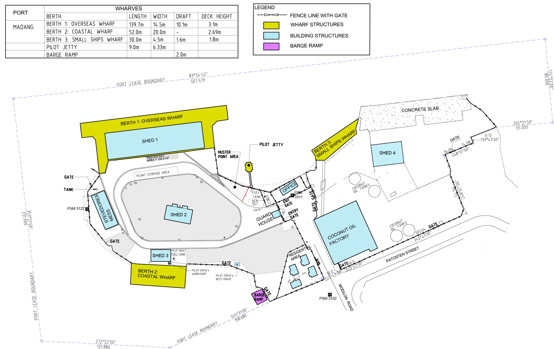
Under cover storage area: Shed 3=200sq.m whereas shed 2 and 4 on lease. Total shed area= 890sq.m.
Open storage areas: Western yard (current operational area) is = 7, 780sq.m. Eastern yard (at old wharf) = 3, 250sq.m.
BUNKER PROVIDER
Main fuel providers are: Mobil, Puma Energy and Island Petroleum Limited. Bunker can be done via road tankers and thought manifold connection at international berth 01 and coastal berth 02. Fuel pipe connection into coastal berth 02 is solely owned and operated by Puma Energy.
WATER PROVIDER
Main water supplier into Port facility is from Water PNG Limited. PNG Ports Madang as a service provider supplies clean treated water via metered pipes and hoses. Water request should be lodged by agents notifying Ports for water accessible via pipeline at berths 1 & 2 only.
Berth Length Width Water depth (below LAT) Deck height (above LAT)
1. Overseas 137m 12.8m 10.1m 3.1m
2. Small Ships 30m 4.5m 1.6m 1.8m
Barge ramp 2.0
WHARF TECHNICAL INFORMATION
Berth Distributed
Tons per sq. Road Vehicle
Truck Semi-trailer Forklift
Berth 1 2.44 T17 ST28 F10
Berth 3 0.97 T6 - F2
Barge Ramp
PERMISSIBLE LOADINGS
PILOTAGE SERVICE
Pilotage is compulsory. Marine Pilots are available and based in Madang.
PILOTAGE MOVEMENT TIMING AND RESTRICTIONS
Pilotage Movement Times is restricted to daylight hours only.
Incoming ships: Between 0600 -1800 hours
Outgoing ships other than tankers: 0600 – 2200 hours.
All Motor Tankers: 0600 -1800 hours movements only (in & out).
PILOT BOARDING GROUND
Lat: 05°13.27’ S, Long: 145° 50.22' E, Kalibobo Light House Bearing 292° (T) x 1.43 Naut.Miles
PILOTAGE BOARDING ARRANGEMENTS
Boarding speed limit: 3-4 Knots with two main ropes or pilot combinations. Port Control or pilot to instruct vessel.
COMMUNICATION ARRAGEMENTS
Radio Call "Madang Port Control" on VHF Channel 12/16.
TUG, TOWAGE, MOORING GANGS SERVICES
Privately owned and operated under license issued by PNG Harbors Management Services a division of PNG PORTS Corporation Limited. Arrangements can be made with private operators through shipping agents.
WHARF CRANES
There are no wharf mounted container handling cranes therefore ships’ cranes are utilized frequently. Any portable shore crane to be engaged should sought approval form PNG Ports prior operating. Shore forklifts, reach stackers, trucks for handling 40 & 20 containers available.
SLIPWAY, SHIP REPAIRS & MAINTENANCE
A new dry dock facility operated by Curtain Brothers is located at Motukea near Port Moresby. Currently it can handle ships of 120m LOA and 4,500 DWT. And by 2014 this dry dock should cater for panamax size ships of 230m LOA and 60, 000 DWT.
However smaller vessels of maximum 40m LOA and 3,000 DWT can slipped at Madang Slipway inside Madang Harbor, own and operated by East New Britain Port Services Ltd.
ANCHORAGE LOCATION (IN COORDINATES)
Outer Anchorage (Near Kranget Island) - Latitude: 05°12.18'S, Longitude: 145°48.58'E
Inner Anchorage (Inside Yamilon Habor) restricted for vessel below 50m only: Latitude: 05°07.30'S, Longitude: 145°49.00'E / Chart No: AUS 646.
OTHER GENERAL INFORMATION
Reefer Container Power Points: Currently there are 27 x reefer power points available.
Electricity: Electricity is 24/7 from PNG Power Limited. In instance where electricity outage in Madang, Ports have a 300KVA standby genset to electrify entire port areas. Also, solar lights recently installed around newly perimeter fence line.
Fencing: New palisade fence installed in 2020 under ports rollout program- TSSP security upgrade program.
Pavement: Upgrade pavement cover almost entire port area and up to standard for smooth yard activities.
Port Office: New port office is currently undergoing construction by contractor Mekemo Brothers Ltd.
Wind Directions: Mostly South Easterly Winds and North Easterly Winds.
Swells: Not encountered in Port Area
SERVICE PROVIDERS
Bismark Maritime Shipping Stevedores
P. O. Box 255 Madang
Telephone: 422 0636
Email: bismarkmaritime.madang@gmail.comJoint Venture Port Services
P. O. Box 226 Madang
Telephone: 422 2865/ 422 2225
Email: Manager@tps.com.pgS.F. Mooring Services
P. O. Box 606 Madang
Telephone: 422 2446
Facsimile: 422 2382Nuxy Mooring Services
P. O. Box 601 Madang
Telephone: 422 1070; Mobile: (675) 71866623
Facsimile: 422 1050
Email: nuxymoor@datec.net.pgPacific Towing Services Limited
P. O. Box 708, Port Moresby, NCD.
Telephone: 3211 206
Email: pactowmadang@hotmail.com
CONTACT INFORMATION
Official | Office |
|---|---|
Business Manager | +675 4222351 / +675 422 352 |
Marine Pilot (Harbour) | +675 422 2351 (Extn 12) |
Customs (Collector) | +675 422 1559 / +675 422 2519 |
Health Officer | +675 422 0000 |
Quarantine Officer | +675 422 2963 |
Fire | +675 422 2777 / +675 422 2245 |
Police | +675 422 3233 / +675 422 3243 |
Ambulance | +675 422 2022 |
Emergency | 000 |
MADANG PORT LAYOUT

