PORT OF WEWAK
The Port of Wewak (above) is located on the Northern Coast of East Sepik Province. The Port is crucial for the local economy. It facilitates the movement of goods and services within the region.
GENERAL PORT INFORMATION.
Location | Latitude: 02° 41.09'S Longitude: 141° 17.84’E |
Chart No. | AUS 651 |
Regional Port | Wewak |
Time Zone | Local time is 10 hours ahead of GMT |
Radio Communication | "Call "Wewak Port Control" on VHF 16.12 |
Customs | Port of entry |
PILOTAGE
Pilotage is Non-compulsory. Pilotage is provided upon request. Refer to NMSA for list of Pilot Service Providers.
TUGS
None available. However arrangements can be done via the Pacific Towing Office based in Port Moresby.
BUNKERS
Fuel is available by road tankers and pipelines.
PORT SECURITY (24/7)
All Commercial vessels with a gross tonnage of 500 tons or more and passenger ships are required to report their security information to Port Control/VTS in respective Ports.
WASTE DISPOSAL
Waste disposal facility is not available. Certain waste/garbage is allowed outside Port via authorized dealers.
Arrangement can be done with licensed Shipping Agents. Seek approval from the Port Manager.
STORAGE AREA
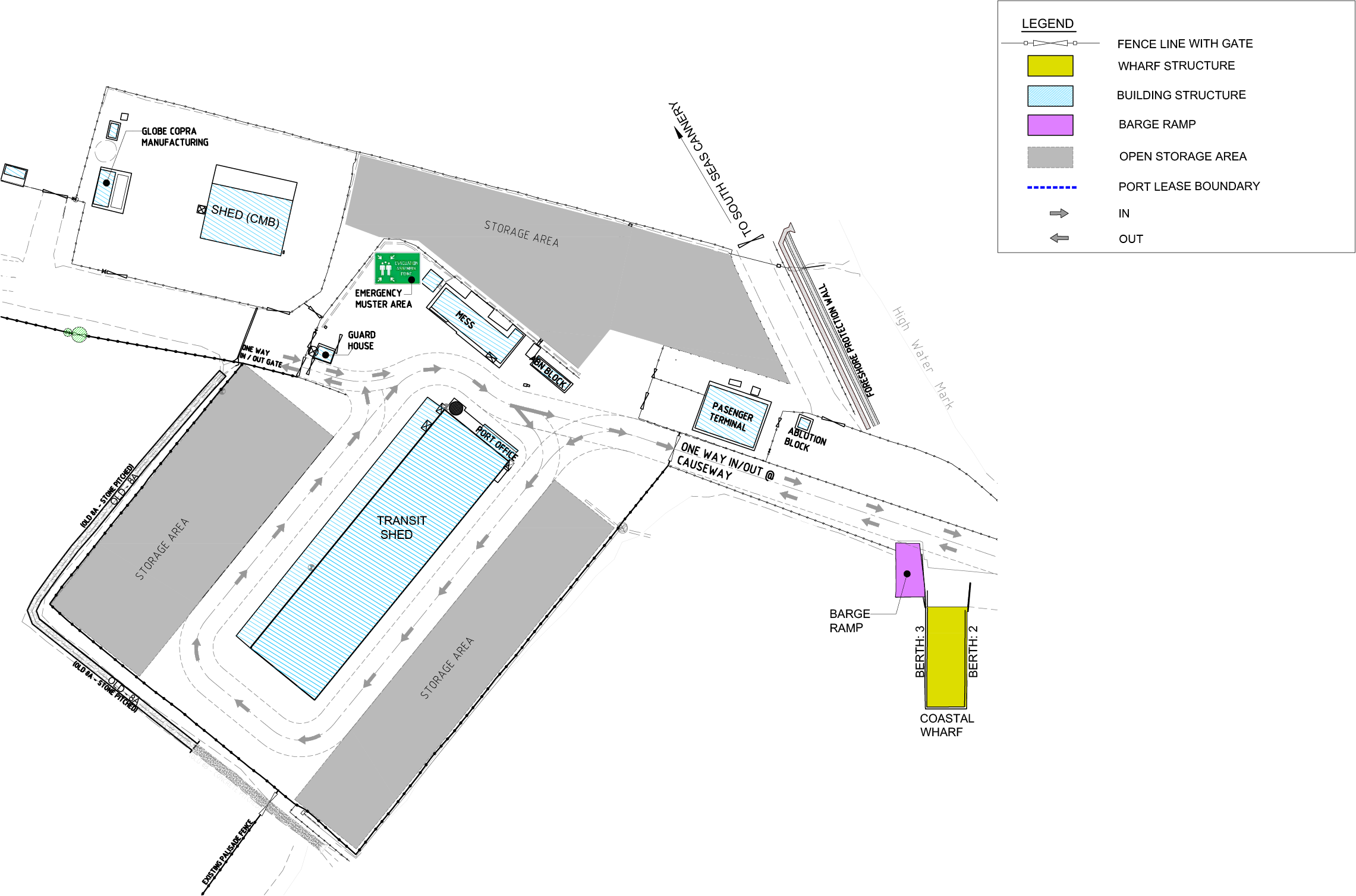
Under cover storage 2220m2
Open storage 11500m2
BUNKER PROVIDER
Suppliers: Inter Oil Products Ltd and Islands Petroleum Ltd.
WATER PROVIDER
Water is provided on request by PNGPCL Facility Operator at Berth.
BALLAST WATER INFORMATION
Ship ballast water are allowed in PNG Port Waters subject to NMSA Approval.
TIDE & TIDAL INFORMATION
Refer to Australian National Tide Table.
Maximum Draft in Channel (Saltwater) – 9.0m
Channel Depth of Water at Chart Datum (Zero Tide) – 9.8m
Under keel Clearance (UKL): 10% Of Draft
Channel Tidal Range: 1.20.
WHARF TECHNICAL INFORMATION
Berth | Length | Width | Water depth (below LAT) | Deck height (above LAT) | Vessel Size (LOA) | Vessel Size (Dead Weight) |
|---|---|---|---|---|---|---|
Overseas (B1) | 73m | 12.1m | 6.2m | 3.5m | 110M | 40,000 |
Coastal (B2 & B3) | 30m | 12.5m | 3.0m | 1.3m | 30M |
PERMISSIBLE LOADINGS
Berth | Distributed Tons per sq. | Road Vehicle | Road Vehicle | Road Vehicle |
|---|---|---|---|---|
Truck | Semi-trailer | Forklift | ||
Berth 1 | 2.2 | T17 | ST28 | F7 |
Berth 2 & 3 | 2.2 | T17 | F5 |
PILOTAGE SERVICE
Pilotage is non-compulsory. Pilotage is provided upon request. Refer to NMSA for list of Pilot Service Providers.
PILOTAGE BOARDING STATION
Latitude: 09° 31.95’S
Longitude: 143° 39.5’E
COMMUNICATION ARRAGEMENTS
Radio Call "Wewak Port Control" on VHF Channel 16/12;
TUG, TOWAGE, MOORING GANGS SERVICES
Privately owned and operated under license issued by the PNG Ports Corporation Limited. Arrangements can be made with Private Operators through the respective Shipping Agents.
WHARF CRANES
No Cranes available.
SLIPWAY, SHIP REPAIRS & MAINTENANCE
None Available
ANCHORAGE LOCATION (IN COORDINATES)
Lat: 10° 19.6'S Long: 150° 27'E. Sanderson Bay Light Ho Bearing 0245 ½ Tx 0.61M
BULK HANDLING, RO-RO, TANKER, LNG (LIQUEFIED NATURAL GAS). PASSENGER HANDLING AND HEAVY LIFT
Available: Bulk Handling & Passenger Handling
CARGO HANDLING FACILITIES
Available: Container & Bulk Handling
CONTACT INFORMATION
Official | Office |
|---|---|
Business Manager | +675 456 2298 |
Port Control | +675 75903029 |
Customs (Collector) | +675 856 1330 / +675 856 2270 |
NAQIA | +675 456 1844 |
Fire | +675 456 2122 / +675 456 2311 |
Police | +675 456 2222 |
Ambulance | 111 |
Emergency | 000 |
WEWAK PORT LAYOUT

